Geolocate

Autonomous Republic of Adjara topographic map

Interactive map

Click on the map to display elevation.

About this map

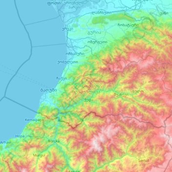
Name: Autonomous Republic of Adjara topographic map, elevation, terrain.

Location: Autonomous Republic of Adjara, Georgia (41.43057 41.29944 41.91193 42.60272)

Average elevation: 802 m

Minimum elevation: -2 m

Maximum elevation: 3,345 m

Other topographic maps

Click on a map to view its topography, its elevation and its terrain.

Tbilisi

Georgia

Tbilisi, Georgia

Average elevation: 757 m

Stepantsminda

Georgia > Mtskheta-Mtianeti > Stepantsminda

Stepantsminda, Kazbegi Municipality, Mtskheta-Mtianeti, Georgia

Average elevation: 1,855 m

Ushba

Georgia > Samegrelo-Upper Svaneti

Ushba, Mestia Municipality, Samegrelo-Upper Svaneti, Georgia

Average elevation: 3,640 m

Shkhara

Georgia > Samegrelo-Upper Svaneti

Shkhara, Mestia Municipality, Samegrelo-Upper Svaneti, Georgia

Average elevation: 4,334 m

Tsaneri Glacier

Georgia > Samegrelo-Upper Svaneti

Tsaneri Glacier, Mestia Municipality, Samegrelo-Upper Svaneti, Georgia

Average elevation: 3,592 m

Zhabeshi

Georgia > Samegrelo-Upper Svaneti > Zhabeshi

Zhabeshi, Mestia Municipality, Samegrelo-Upper Svaneti, Georgia

Average elevation: 1,990 m

Caucasus Mountains

Georgia > Mtskheta-Mtianeti

Caucasus Mountains, Dusheti Municipality, Mtskheta-Mtianeti, Georgia

Average elevation: 2,188 m

Mount Mkinvartsveri (Kazbegi)

Georgia > Mtskheta-Mtianeti

Mount Mkinvartsveri (Kazbegi), Kazbegi Municipality, Mtskheta-Mtianeti, Georgia

Average elevation: 4,324 m

Lekhziri Glacier

Georgia > Samegrelo-Upper Svaneti

Lekhziri Glacier, Mestia Municipality, Samegrelo-Upper Svaneti, Georgia

Average elevation: 3,061 m