
Little Saskatchewan River topographic map
Interactive map
Click on the map to display elevation.
About this map
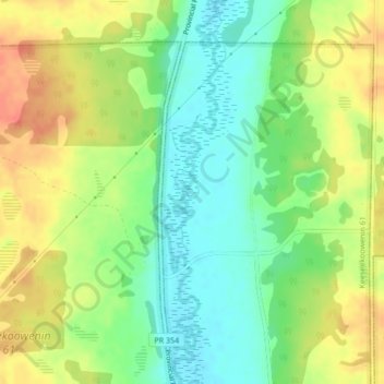
Name: Little Saskatchewan River topographic map, elevation, terrain.
Location: Little Saskatchewan River, Manitoba, Canada (50.56888 -100.29852 50.56974 -100.29695)
Average elevation: 572 m
Minimum elevation: 549 m
Maximum elevation: 599 m
Other topographic maps
Click on a map to view its topography, its elevation and its terrain.
Winnipeg
Winnipeg lies at the bottom of the Red River Valley, a flood plain with an extremely flat topography. It is on the eastern edge of the Canadian Prairies in Western Canada and is known as the "Gateway to the West". Winnipeg is bordered by tallgrass prairie to the west and south and the aspen parkland to the…
Average elevation: 236 m
Peguis First Nation
Canada > Manitoba > Unorganized Division No. 19 > Dallas/Red Rose
Average elevation: 247 m
Pelican Lake
Canada > Manitoba > Municipality of Killarney-Turtle Mountain
The lake is normally maintained at elevations between 411.5 and 412 metres (1,350 and 1,352 ft) above sea level during summer months. During the spring period, the lake may be raised temporarily to an elevation of 412.2 metres (1,352 ft). When the lake is low, water may be diverted from the Pembina River into…
Average elevation: 459 m
Wasagaming
Canada > Manitoba > Unorganized Division No. 17
Wasagaming has a subarctic climate (Dfc) due to its northerly location and high elevation. Winters are extremely cold and relatively dry with little chance of a mid-winter thaw. The average annual temperature is 0.7 °C (33.3 °F). Annual precipitation is 488 mm (19.2 in).
Average elevation: 630 m
Winnipeg
Winnipeg lies at the bottom of the Red River Valley, a flood plain with an extremely flat topography. It is on the eastern edge of the Canadian Prairies in Western Canada and is known as the "Gateway to the West". Winnipeg is bordered by tallgrass prairie to the west and south and the aspen parkland to the…
Average elevation: 236 m
Garden Hill (Kistiganwacheeng)
Canada > Manitoba > Unorganized Division No. 22
Average elevation: 235 m
Winnipeg
Winnipeg lies at the bottom of the Red River Valley, a flood plain with an extremely flat topography. It is on the eastern edge of the Canadian Prairies in Western Canada and is known as the "Gateway to the West". Winnipeg is bordered by tallgrass prairie to the west and south and the aspen parkland to the…
Average elevation: 236 m
West Shoal Lake
Canada > Manitoba > Division No. 18 > Rural Municipality of St. Laurent
Average elevation: 262 m
Winnipeg
Winnipeg lies at the bottom of the Red River Valley, a flood plain with an extremely flat topography. It is on the eastern edge of the Canadian Prairies in Western Canada and is known as the "Gateway to the West". Winnipeg is bordered by tallgrass prairie to the west and south and the aspen parkland to the…
Average elevation: 236 m
Swan Lake
Canada > Manitoba > Unorganized Division No. 19
The Swan Lake drainage basin covers 3,880 square miles (10,000 km2) and extends into the province of Saskatchewan. It is located between the Duck Mountains and the Porcupine Hills. Two major rivers discharge into Swan Lake from the basin, the Swan River and the Woody River. Other topographic features include…
Average elevation: 269 m
Stonewall
When the last ice age retreated, as well as the prairies, escarpments such as Riding Mountain were left behind. In addition to these, smaller elevations were left behind such as Stony Mountain and Stonewall. It is believed that these escarpments were used as look-outs by early hunters approximately 4,000 to…
Average elevation: 251 m