
Vlotho topographic map
Interactive map
Click on the map to display elevation.
About this map
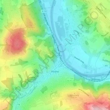
Name: Vlotho topographic map, elevation, terrain.
Location: Vlotho, Kreis Herford, Nordrhein-Westfalen, 32602, Deutschland (52.15440 8.83857 52.18889 8.89170)
Average elevation: 119 m
Minimum elevation: 42 m
Maximum elevation: 268 m
Other topographic maps
Click on a map to view its topography, its elevation and its terrain.
Bonneberg
Deutschland > Nordrhein-Westfalen > Kreis Herford > Vlotho
Bonneberg, Vlotho, Kreis Herford, Nordrhein-Westfalen, 32602, Deutschland
Average elevation: 150 m
NSG Eiberg
Deutschland > Nordrhein-Westfalen > Kreis Herford > Vlotho
NSG Eiberg, Lemgoer Straße, Beerenkämpen, Valdorf, Vlotho, Kreis Herford, Nordrhein-Westfalen, 32602, Deutschland
Average elevation: 166 m
Uffeln
Deutschland > Nordrhein-Westfalen > Kreis Herford > Vlotho
Uffeln, Vlotho, Kreis Herford, Nordrhein-Westfalen, Deutschland
Average elevation: 104 m
Exter
Deutschland > Nordrhein-Westfalen > Kreis Herford > Vlotho
Exter, Vlotho, Kreis Herford, Nordrhein-Westfalen, Deutschland
Average elevation: 159 m