
Munich topographic map
Interactive map
Click on the map to display elevation.
About this map
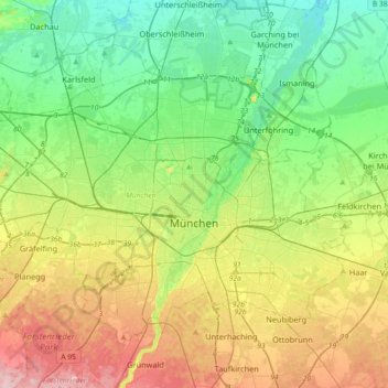
Name: Munich topographic map, elevation, terrain.
Location: Munich, Bavaria, Germany (48.06162 11.36078 48.24812 11.72291)
Average elevation: 524 m
Minimum elevation: 466 m
Maximum elevation: 633 m
Munich lies on the elevated plains of Upper Bavaria, about 50 km (31 mi) north of the northern edge of the Alps, at an altitude of about 520 m (1,706 ft) ASL. The local rivers are the Isar and the Würm. Munich is situated in the Northern Alpine Foreland. The northern part of this sandy plateau includes a highly fertile flint area which is no longer affected by the folding processes found in the Alps, while the southern part is covered with morainic hills. Between these are fields of fluvio-glacial out-wash, such as around Munich. Wherever these deposits get thinner, the ground water can permeate the gravel surface and flood the area, leading to marshes as in the north of Munich.
Other topographic maps
Click on a map to view its topography, its elevation and its terrain.
Tegernsee
Germany > Bavaria > Landkreis Miesbach
Tegernsee, Landkreis Miesbach, Bavaria, 83684, Germany
Average elevation: 858 m
Berchtesgaden Alps
Berchtesgaden Alps, Ramsau, Landkreis Berchtesgadener Land, Upper Bavaria, Bavaria, Germany
Average elevation: 1,158 m
Wetterstein
Germany > Bavaria > Garmisch-Partenkirchen
Wetterstein, Garmisch-Partenkirchen, Landkreis Garmisch-Partenkirchen, Upper Bavaria, Bavaria, Germany
Average elevation: 1,346 m
Untersberg
Germany > Bavaria > Schellenberger Forst
Untersberg, Schellenberger Forst, Landkreis Berchtesgadener Land, Upper Bavaria, Bavaria, Germany
Average elevation: 798 m
Hanging
Germany > Bavaria > Landkreis Mühldorf am Inn > Hanging
Hanging, Oberbergkirchen (VGem), Landkreis Mühldorf am Inn, Upper Bavaria, Bavaria, 84573, Germany
Average elevation: 467 m
Marienberg
Marienberg, Würzburg, Lower Franconia, Bavaria, 97082, Germany
Average elevation: 214 m