
Ontonagon County topographic map
Interactive map
Click on the map to display elevation.
About this map
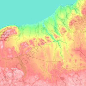
Name: Ontonagon County topographic map, elevation, terrain.
Location: Ontonagon County, Michigan, United States of America (46.33230 -89.88806 47.03128 -88.86374)
Average elevation: 334 m
Minimum elevation: 174 m
Maximum elevation: 587 m
Other topographic maps
Click on a map to view its topography, its elevation and its terrain.
Genesee County
United States of America > Michigan
Genesee County, Michigan, United States of America
Average elevation: 246 m
Sanilac County
United States of America > Michigan
Sanilac County, Michigan, United States of America
Average elevation: 228 m
Ingham County
United States of America > Michigan
Ingham County, Michigan, United States of America
Average elevation: 278 m
East Lansing
United States of America > Michigan > East Lansing > East Lansing
East Lansing, Ingham County, Michigan, United States of America
Average elevation: 261 m