
Shivpuri topographic map
Interactive map
Click on the map to display elevation.
About this map
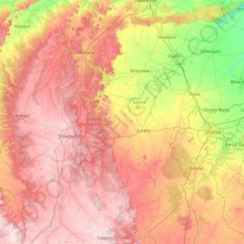
Name: Shivpuri topographic map, elevation, terrain.
Location: Shivpuri, Shivpuri district, Madhya Pradesh, India (24.86000 77.36000 26.14000 78.64000)
Average elevation: 332 m
Minimum elevation: 139 m
Maximum elevation: 524 m
Other topographic maps
Click on a map to view its topography, its elevation and its terrain.
Turiya
India > Madhya Pradesh > Turiya
Turiya, Kurai Tahsil, Seoni, Madhya Pradesh, India
Average elevation: 428 m
Narmada
Narmada, Hoshangābād, Hoshangabad, Madhya Pradesh, 481880, India
Average elevation: 380 m
Hoshangābād
Hoshangābād, Hoshangabad, Madhya Pradesh, 461111, India
Average elevation: 427 m
Sagar
India > Madhya Pradesh > Sagar
Sagar, Sagar Tahsil, Sagar, Madhya Pradesh, 470001, India
Average elevation: 515 m