
Handa topographic map
Interactive map
Click on the map to display elevation.
About this map
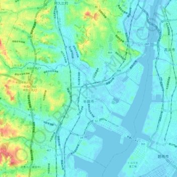
Name: Handa topographic map, elevation, terrain.
Location: Handa, Aichi Prefecture, Chubu Region, Japan (34.85897 136.86560 34.94175 136.97828)
Average elevation: 15 m
Minimum elevation: -4 m
Maximum elevation: 77 m
Other topographic maps
Click on a map to view its topography, its elevation and its terrain.
湊入船町
Japan > Chubu Region > Toyama > 湊入船町
湊入船町, Toyama, Toyama Prefecture, Chubu Region, 930-0001, Japan
Average elevation: 13 m