
Podlaskie Voivodeship topographic map
Interactive map
Click on the map to display elevation.
About this map
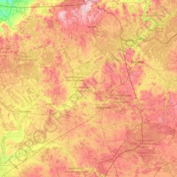
Name: Podlaskie Voivodeship topographic map, elevation, terrain.
Location: Podlaskie Voivodeship, Poland (52.27994 21.59284 54.41040 23.94628)
Average elevation: 138 m
Minimum elevation: 30 m
Maximum elevation: 290 m
It has a varied landscape, shaped in the north by Baltic glaciation, the rest by Middle Poland glaciation. The highest peaks are in the north (Rowelska Top - 298 m), where the landscape is dominated by a hilly lake district. Lakeland: Zachodniosuwalskie, Wschodniosuwalskie, Ełckie) and Sandrowy lake district (Augustów Plain) in the central and southern pre-glacial plains prevail (plateaus: Kolneńska, Białystok, Wysokomazowiecka, Drohiczynska, Sokólskie Hills, Międzyrzecko łomżyński, Plain Bielsko), varied in topography with small basins and river valleys. Kurpie lie on the west edge of the outwash plains. Sand, gravel, clay, moraine, and in the valleys and basins of the rivers silt, sand and river peat predominate on the surface.
Other topographic maps
Click on a map to view its topography, its elevation and its terrain.
Mińsk County
Mińsk County, Masovian Voivodeship, Poland
Average elevation: 143 m
Elk
Poland > Warmian-Masurian Voivodeship > Elk
Elk, powiat ełcki, Warmian-Masurian Voivodeship, Poland
Average elevation: 129 m
Przystań
Poland > Warmian-Masurian Voivodeship > Przystań
Przystań, gmina Węgorzewo, powiat węgorzewski, Warmian-Masurian Voivodeship, 11-600, Poland
Average elevation: 121 m
Góra
Poland > Lower Silesian Voivodeship > Góra
Góra, gmina Góra, powiat górowski, Lower Silesian Voivodeship, 56-200, Poland
Average elevation: 93 m
772
Poland > Lower Silesian Voivodeship > Grzmiąca
772, Grzmiąca, gmina Głuszyca, powiat wałbrzyski, Lower Silesian Voivodeship, 58-330, Poland
Average elevation: 648 m
Okiersk
Poland > Kuyavian-Pomeranian Voivodeship > Okiersk
Okiersk, gmina Cekcyn, powiat tucholski, Kuyavian-Pomeranian Voivodeship, 89-511, Poland
Average elevation: 113 m
Kłodzko
Poland > Lower Silesian Voivodeship > Kłodzko
Kłodzko, powiat kłodzki, Lower Silesian Voivodeship, 57-300, Poland
Average elevation: 332 m
powiat jeleniogórski
Poland > Lower Silesian Voivodeship
powiat jeleniogórski, Lower Silesian Voivodeship, Poland
Average elevation: 606 m
Praga-Południe
Poland > Masovian Voivodeship > Warsaw
Praga-Południe, Warsaw, Warszawa, Masovian Voivodeship, Poland
Average elevation: 86 m
Sejny
Poland > Podlaskie Voivodeship > Sejny
Sejny, powiat sejneński, Podlaskie Voivodeship, 16-500, Poland
Average elevation: 136 m
Lipno
Poland > Kuyavian-Pomeranian Voivodeship > Lipno
Lipno, Lipno County, Kuyavian-Pomeranian Voivodeship, Poland
Average elevation: 103 m
Mrągowo
Poland > Warmian-Masurian Voivodeship > Mrągowo
Mrągowo, powiat mrągowski, Warmian-Masurian Voivodeship, 11-700, Poland
Average elevation: 150 m
Nowy Targ
Poland > Lesser Poland Voivodeship > Nowy Targ
Nowy Targ, powiat nowotarski, Lesser Poland Voivodeship, Poland
Average elevation: 679 m
Bieszczady
Poland > Lublin Voivodeship > Luchów Górny
Bieszczady, Luchów Górny, gmina Tarnogród, powiat biłgorajski, Lublin Voivodeship, 23-420, Poland
Average elevation: 239 m
Świecie
Poland > Kuyavian-Pomeranian Voivodeship > Świecie
Świecie, gmina Świecie, powiat świecki, Kuyavian-Pomeranian Voivodeship, 86-101, Poland
Average elevation: 44 m