
Odisha topographic map
Interactive map
Click on the map to display elevation.
About this map
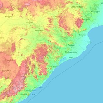
Name: Odisha topographic map, elevation, terrain.
Location: Odisha, India (17.79490 81.38859 22.56759 87.48580)
Average elevation: 227 m
Minimum elevation: -1 m
Maximum elevation: 1,584 m
Three-quarters of the state is covered in mountain ranges. Deep and broad valleys have been made in them by rivers. These valleys have fertile soil and are densely populated. Odisha also has plateaus and rolling uplands, which have lower elevation than the plateaus. The highest point in the state is Deomali at 1,672 metres. The other high peaks are: Sinkaram (1,620 m), Golikoda (1,617 m), and Yendrika (1,582 metres).
Other topographic maps
Click on a map to view its topography, its elevation and its terrain.
Kargil Tehsil
Kargil Tehsil, Kargil district, Ladakh, 194103, India
Average elevation: 4,005 m
Zemu Glacier
Zemu Glacier, North District, North Sikkim District, Sikkim, India
Average elevation: 5,499 m
Yanam
India > Puducherry > Yanam
Yanam, Yanam Taluk, Yanam District, Puducherry, 533464, India
Average elevation: 5 m
Howrah
India > West Bengal > Howrah
Howrah, Haora, Howrah, West Bengal, 711101, India
Average elevation: 5 m
Dharasuram
India > Tamil Nadu > Dharasuram
Dharasuram, Thanjavur district, Tamil Nadu, 612001, India
Average elevation: 28 m
Mansarovar
India > Gujarat > Mansarovar
Mansarovar, Becharaji Taluka, Mahesana District, Gujarat, 384210, India
Average elevation: 46 m
Turiya
India > Madhya Pradesh > Turiya
Turiya, Kurai Tahsil, Seoni, Madhya Pradesh, India
Average elevation: 428 m
Adirampattinam
India > Tamil Nadu > Adirampattinam
Adirampattinam, Thanjavur district, Tamil Nadu, 614701, India
Average elevation: 5 m
Chinchwad
India > Maharashtra > Chinchwad
Chinchwad, Kolhapur, Maharashtra, 416112, India
Average elevation: 548 m
Sarkaghat
India > Himachal Pradesh > Sarkaghat
Sarkaghat, Hamirpur, Himachal Pradesh, 175024, India
Average elevation: 1,014 m
Central Zone
India > Tamil Nadu > Nanjundapuram
Central Zone, Nanjundapuram, Coimbatore district, Tamil Nadu, 641045, India
Average elevation: 399 m
Gurudev Nagar
India > Telangana > Gurudev Nagar
Gurudev Nagar, Boath mandal, Adilabad, Telangana, India
Average elevation: 467 m
New Town
India > West Bengal > New Town
New Town, Twenty-four Parganas, North 24 Parganas, West Bengal, 700161, India
Average elevation: 3 m
Karjat
India > Maharashtra > Karjat
Karjat, Kulāba, Raigad, Maharashtra, 410201, India
Average elevation: 109 m
Kamalapura
India > Karnataka > Kamalapura
Kamalapura, Hosapete taluk, Bellary district, Karnataka, 583221, India
Average elevation: 456 m
Udhagamandalam
India > Tamil Nadu > Udhagamandalam
Udhagamandalam, The Nilgiris, The Nilgiris district, Tamil Nadu, 643001, India
Average elevation: 2,234 m
Sonamarg
India > Jammu and Kashmir > Sonamarg
Sonamarg, Ganderbal, Jammu and Kashmir, India
Average elevation: 3,354 m