
Metropolitan City of Florence topographic map
Interactive map
Click on the map to display elevation.
About this map
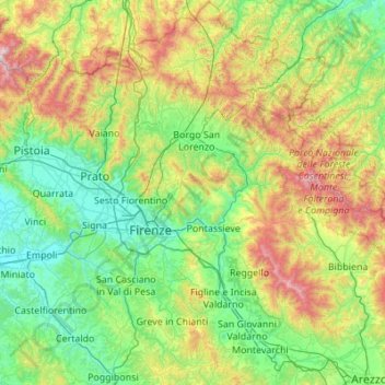
Name: Metropolitan City of Florence topographic map, elevation, terrain.
Location: Metropolitan City of Florence, Tuscany, Italy (43.45144 10.71112 44.23990 11.75294)
Average elevation: 456 m
Minimum elevation: 11 m
Maximum elevation: 1,901 m
Other topographic maps
Click on a map to view its topography, its elevation and its terrain.
Castel del Piano
Italy > Tuscany > Castel del Piano
Castel del Piano, Unione dei Comuni Montani Amiata Grossetana, GR, Tuscany, 58033, Italy
Average elevation: 561 m