
Río Gallegos topographic map
Interactive map
Click on the map to display elevation.
About this map
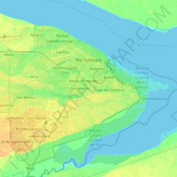
Name: Río Gallegos topographic map, elevation, terrain.
Location: Río Gallegos, Güer Aike, SC, Argentina (-51.68368 -69.36395 -51.60083 -69.17721)
Average elevation: 9 m
Minimum elevation: 0 m
Maximum elevation: 26 m
Other topographic maps
Click on a map to view its topography, its elevation and its terrain.
San Martín
Argentina > SC > Río Gallegos
San Martín, Río Gallegos, Güer Aike, SC, Argentina
Average elevation: 14 m