
Nassau County topographic map
Interactive map
Click on the map to display elevation.
About this map
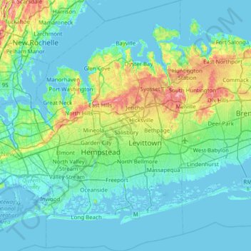
Name: Nassau County topographic map, elevation, terrain.
Location: Nassau County, New York, United States of America (40.52330 -73.78042 40.96420 -73.42314)
Average elevation: 18 m
Minimum elevation: -6 m
Maximum elevation: 111 m
Other topographic maps
Click on a map to view its topography, its elevation and its terrain.
Saratoga County
United States of America > New York
Saratoga County, New York, United States of America
Average elevation: 218 m
Farmingville
United States of America > New York
Farmingville, Suffolk County, New York, 11738, United States of America
Average elevation: 47 m
Queens
United States of America > New York > New York
Queens, New York, United States of America
Average elevation: 11 m
Saint Lawrence
United States of America > New York
Saint Lawrence, New York, United States of America
Average elevation: 239 m
Essex County
United States of America > New York
Essex County, New York, United States of America
Average elevation: 418 m
Allegany County
United States of America > New York
Allegany County, New York, United States of America
Average elevation: 561 m
Valley Stream
United States of America > New York > Valley Stream > Valley Stream
Valley Stream, Hempstead, Nassau County, New York, 11580, United States of America
Average elevation: 7 m
New York County
United States of America > New York > New York
New York County, New York, United States of America
Average elevation: 16 m