
Mérida topographic map
Interactive map
Click on the map to display elevation.
About this map
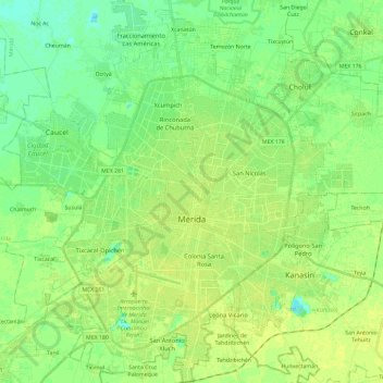
Name: Mérida topographic map, elevation, terrain.
Location: Mérida, Yucatán, Mexico (20.87331 -89.72620 21.09205 -89.53017)
Average elevation: 9 m
Minimum elevation: 1 m
Maximum elevation: 15 m
The city is located near the center of the Chicxulub Crater. It has a very flat topography and is only 9 metres (30 ft) above sea level. The land outside of Mérida is covered with smaller scrub trees and former henequen fields. Almost no surface water exists, but several cenotes (sinkholes that provide access to underground springs and rivers) are found in the area.