
León topographic map
Interactive map
Click on the map to display elevation.
About this map
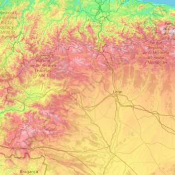
Name: León topographic map, elevation, terrain.
Location: León, Castile and León, Spain (42.02928 -7.07707 43.23820 -4.73236)
Average elevation: 913 m
Minimum elevation: 0 m
Maximum elevation: 2,527 m
As for the temperatures, in general it is a cold climate due to the altitude and the abundance of frost (which persist from November to May), being more intense in the mountainous areas reaching -18 °C. Vega de Liordes, an enclave in the León sector of Picos de Europa belonging to the municipality of Posada de Valdeón registered −35.8 °C (−32.4 °F) on January 7, 2021.
Other topographic maps
Click on a map to view its topography, its elevation and its terrain.
Burgos
Spain > Castile and León > Burgos
Burgos, Alfoz de Burgos, Burgos, Castile and León, Spain
Average elevation: 907 m
Buenavista
Spain > Castile and León > Buenavista > Buenavista
Buenavista, Tierra de Alba, Salamanca, Castile and León, 37789, Spain
Average elevation: 924 m
Dehesa de Perosín
Spain > Castile and León > Peñaparda
Dehesa de Perosín, Peñaparda, Comarca de Ciudad Rodrigo, Salamanca, Castile and León, 37524, Spain
Average elevation: 862 m
Puebla de Lillo
Spain > Castile and León > Puebla de Lillo
Puebla de Lillo, León, Castile and León, 24855, Spain
Average elevation: 1,461 m
Contreras
Spain > Castile and León > Contreras
Contreras, Sierra de la Demanda, Burgos, Castile and León, Spain
Average elevation: 1,089 m