
Make a donation
North Sumatra topographic map
Click on the map to display elevation.
Make a donation
North Sumatra
Half of provinces are high plateau that runs by Bukit Barisan mountains range, mainly around central to western coastal of provinces, the tallest mountain in the provinces is Mount Sinabung with elevation around 2,460 mdpl, and it is the most active volcano in the region. Activities of the mountain (cracks where steam, gas, and lava are emitted) were last observed at the summit in 1912; recent documented events include an eruption in the early hours of 29 August 2010 and eruptions in September and November 2013, January, February and October 2014. Another volcano nearby are Mount Sibayak with 2,181 mdpl, the mountain produce crystalline sulfur, which was mined on a small scale in the past. Seepage of sulfurous gases has also caused acidic discolouration of the small crater lake, both of the volcanoes are located in the Karo highland.
Make a donation
About this map
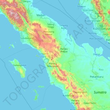
Name: North Sumatra topographic map, elevation, terrain.
Location: North Sumatra, Sumatra, Indonesia (-1.03364 96.72039 4.43955 100.72520)
Average elevation: 200 m
Minimum elevation: -2 m
Maximum elevation: 3,374 m
Make a donation
Other topographic maps
Click on a map to view its topography, its elevation and its terrain.