
Curaçao topographic map
Interactive map
Click on the map to display elevation.
About this map
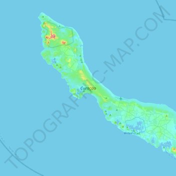
Name: Curaçao topographic map, elevation, terrain.
Location: Curaçao, Curacao, Netherlands (12.03427 -69.16271 12.39273 -68.73664)
Average elevation: 7 m
Minimum elevation: -1 m
Maximum elevation: 322 m
Curaçao, as well as the rest of the ABC islands and Trinidad and Tobago, lies on the continental shelf of South America. It is a thin island with a generally hilly topography; the highest point is Christoffelberg in the northwest, with a peak at 372 m (1,220 ft) above sea level. The coastline's bays, inlets and hot springs offer a source of natural minerals, thermal conditions, and seawater used in hydrotherapy and mesotherapy, making the island one of many balneoclimateric areas in the region. Off the southeast coast lies the small, flat island of Klein Curaçao.
Other topographic maps
Click on a map to view its topography, its elevation and its terrain.
Sint-Michielsgestel
Sint-Michielsgestel, North Brabant, Netherlands
Average elevation: 7 m
Maarssen
Netherlands > Utrecht > Stichtse Vecht
Maarssen, Stichtse Vecht, Utrecht, Netherlands
Average elevation: 1 m
Hof van Twente
Netherlands > Overijssel > Hof van Twente
Hof van Twente, Overijssel, Netherlands
Average elevation: 16 m
Eindhoven
Netherlands > North Brabant > Eindhoven
Eindhoven, North Brabant, Netherlands
Average elevation: 20 m
Driehuizen
Netherlands > North Brabant > Driehuizen
Driehuizen, North Brabant, Netherlands, 5111, Netherlands
Average elevation: 26 m
Camping
Netherlands > Friesland > De Fryske Marren
Camping, De Fryske Marren, Friesland, Netherlands, 8493KN, Netherlands
Average elevation: -1 m
Julianadorp
Netherlands > North Holland > Den Helder
Julianadorp, Den Helder, North Holland, Netherlands
Average elevation: 1 m
Nuenen
Netherlands > North Brabant > Nuenen c.a.
Nuenen, Nuenen c.a., North Brabant, Netherlands
Average elevation: 17 m
Batenburg
Netherlands > Gelderland > Wijchen
Batenburg, Wijchen, Gelderland, Netherlands
Average elevation: 8 m
Naarden
Netherlands > North Holland > Gooise Meren
Naarden, Gooise Meren, North Holland, Netherlands
Average elevation: 2 m
Rotterdam
Netherlands > South Holland > Rotterdam
Rotterdam, South Holland, Netherlands
Average elevation: 0 m
Hoogerheide
Netherlands > North Brabant > Woensdrecht
Hoogerheide, Woensdrecht, North Brabant, Netherlands
Average elevation: 14 m
Horst aan de Maas
Netherlands > Limburg > Horst aan de Maas
Horst aan de Maas, Limburg, Netherlands
Average elevation: 27 m
Zoetermeer
Netherlands > South Holland > Zoetermeer
Zoetermeer, South Holland, Netherlands
Average elevation: -3 m
Noordoostpolder
Netherlands > Flevoland > Noordoostpolder
Noordoostpolder, Flevoland, Netherlands
Average elevation: -1 m
Eindhoven
Netherlands > North Brabant > Eindhoven
Eindhoven, North Brabant, Netherlands
Average elevation: 20 m