
Clontarf West topographic map
Interactive map
Click on the map to display elevation.
About this map
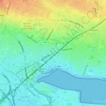
Name: Clontarf West topographic map, elevation, terrain.
Average elevation: 15 m
Minimum elevation: -1 m
Maximum elevation: 41 m
Other topographic maps
Click on a map to view its topography, its elevation and its terrain.
Ballyboggan South
Ballyboggan South, Cabra East A ED, Dublin 11, Dublin, County Dublin, Leinster, Ireland
Average elevation: 41 m
North Bull Island
North Bull Island, Raheny St. Assam ED, Dublin 5, Dublin, County Dublin, Leinster, Ireland
Average elevation: 2 m