
Make a donation
Baja California Sur topographic map
Click on the map to display elevation.
Make a donation
Baja California Sur
The climate of the state is dry, with an average annual temperature of 18–22 °C and average annual rainfall of less than 200mm. The lower elevations are the driest and hottest, with summer daytime temperatures above 40 °C; wintertime temperatures may fall below freezing. The exception to desert conditions is the Los Cabos region, classified as semi-moist because of Pacific hurricane activity which affects the region. In the spring, prevailing winds are from the west and in the summer from the south and southwest. In the fall, they are from the northwest and in the winter from the north and northwest.
Make a donation
About this map
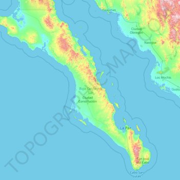
Name: Baja California Sur topographic map, elevation, terrain.
Location: Baja California Sur, Mexico (22.87163 -115.76919 28.00000 -109.41317)
Average elevation: 90 m
Minimum elevation: -5 m
Maximum elevation: 2,265 m
Make a donation
Other topographic maps
Click on a map to view its topography, its elevation and its terrain.