
Kühtai topographic map
Interactive map
Click on the map to display elevation.
About this map
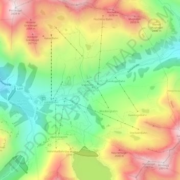
Name: Kühtai topographic map, elevation, terrain.
Location: Kühtai, Silz, Bezirk Imst, Tyrol, 6183, Austria (47.19362 11.00340 47.23362 11.04340)
Average elevation: 2,265 m
Minimum elevation: 1,826 m
Maximum elevation: 2,807 m
Other topographic maps
Click on a map to view its topography, its elevation and its terrain.
Sölden
Austria > Tyrol > Bezirk Imst
The main village of Sölden is at an elevation of 1,368 metres (4,488 ft) above sea level, and the upper village of Hochsölden at 2,090 m (6,857 ft) has 5 four-star hotels. The highest peak is the Wildspitze, at 3,768 m (12,362 ft), the second highest mountain in Austria, after the Großglockner.
Average elevation: 2,483 m