
Thank you for supporting this site ❤️
Make a donation
Make a donation
Sünching topographic map
Click on the map to display elevation.
Thank you for supporting this site ❤️
Make a donation
Make a donation
About this map
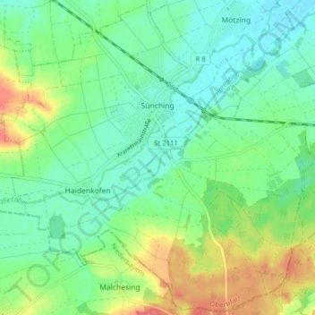
Name: Sünching topographic map, elevation, terrain.
Average elevation: 352 m
Minimum elevation: 331 m
Maximum elevation: 395 m
Thank you for supporting this site ❤️
Make a donation
Make a donation
Other topographic maps
Click on a map to view its topography, its elevation and its terrain.
Stettwies
Deutschland > Bayern > Landkreis Regensburg > Lappersdorf > Lorenzen
Average elevation: 378 m
Irlbründl
Deutschland > Bayern > Landkreis Regensburg > Regenstauf > Kürnberg
Average elevation: 379 m
Thank you for supporting this site ❤️
Make a donation
Make a donation