
Thank you for supporting this site ❤️
Make a donation
Make a donation
Lampung topographic map
Click on the map to display elevation.
Thank you for supporting this site ❤️
Make a donation
Make a donation
Lampung
Between 1969 and 1970, the total area of forest land in Lampung that had been used was 249,200 hectares. In 2000, there were 48 permits issued; in 1980, the number reached 76 permits. The topography of the region in the western part is mostly hilly, while the eastern part is mostly a lowland area that is agricultural and swampy. In 1950, nine specimens per 100 square kilometres in Lampung were collected as part of botanical research.
Thank you for supporting this site ❤️
Make a donation
Make a donation
About this map
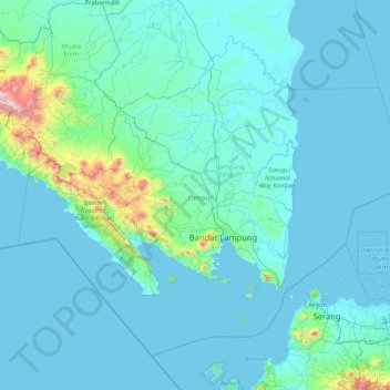
Name: Lampung topographic map, elevation, terrain.
Location: Lampung, Sumatra, Indonesia (-6.45503 103.50688 -3.72374 106.84665)
Average elevation: 111 m
Minimum elevation: -2 m
Maximum elevation: 2,686 m
Thank you for supporting this site ❤️
Make a donation
Make a donation
Other topographic maps
Click on a map to view its topography, its elevation and its terrain.