
Make a donation
Summit County topographic map
Click on the map to display elevation.
Make a donation
Summit County
The terrain of the county is mountainous with elevations ranging from 7,957 feet (2,425 m) at Green Mountain Reservoir to 14,270 feet (4,350 m) at Grays Peak. The elevation of the county seat of Breckenridge is 9,602 feet (2,927 m), making it one of the highest cities in the state of Colorado and the United States. Much of the county has an alpine climate (ET in the Köppen Classification) characterized by tundra vegetation. Breckenridge and other similar elevations in the county have a subarctic climate (Dfc) characterized by cool summers and abundant snowfall in winter.
Make a donation
About this map
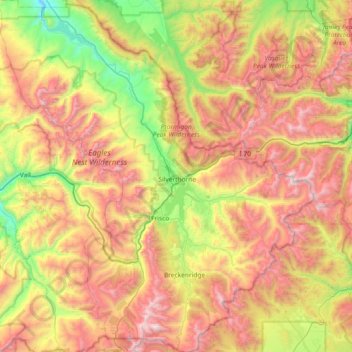
Name: Summit County topographic map, elevation, terrain.
Location: Summit County, Colorado, United States (39.35736 -106.43592 39.92489 -105.77582)
Average elevation: 3,222 m
Minimum elevation: 2,336 m
Maximum elevation: 4,343 m
Make a donation