
Argyll and Bute topographic map
Interactive map
Click on the map to display elevation.
About this map
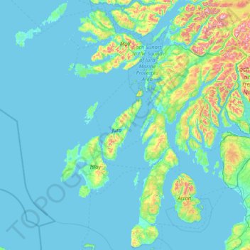
Name: Argyll and Bute topographic map, elevation, terrain.
Location: Argyll and Bute, Scotland, United Kingdom (55.27448 -7.11443 56.70508 -4.55985)
Average elevation: 84 m
Minimum elevation: -1 m
Maximum elevation: 1,105 m
Other topographic maps
Click on a map to view its topography, its elevation and its terrain.
Kirkwall
United Kingdom > Scotland > Orkney Islands
Kirkwall, Orkney Islands, Scotland, KW15 1DH, United Kingdom
Average elevation: 27 m
Challoch
United Kingdom > Scotland > Newton Stewart > Challoch
Challoch, Newton Stewart, Dumfries and Galloway, Scotland, DG8 6RB, United Kingdom
Average elevation: 55 m
Cairngarroch
Cairngarroch, Dumfries and Galloway, Scotland, DG9 9EQ, United Kingdom
Average elevation: 85 m
Stoneykirk
United Kingdom > Scotland > Stoneykirk
Stoneykirk, Dumfries and Galloway, Scotland, DG9 9DJ, United Kingdom
Average elevation: 38 m
Newmains
United Kingdom > Scotland > Newmains
Newmains, North Lanarkshire, Scotland, ML2 9AX, United Kingdom
Average elevation: 163 m
River Affric
River Affric, Highland, Scotland, IV4 7NB, United Kingdom
Average elevation: 266 m
Ayr
United Kingdom > Scotland > Ayr
Ayr, South Ayrshire, Scotland, KA7 1JX, United Kingdom
Average elevation: 16 m
Edinburgh
United Kingdom > Scotland > Edinburgh
Edinburgh, City of Edinburgh, Scotland, EH1 1BB, United Kingdom
Average elevation: 105 m
Fishwick
United Kingdom > Scotland > Fishwick
Fishwick, Scottish Borders, Scotland, TD15 1XQ, United Kingdom
Average elevation: 40 m
Mull
Mull, Argyll and Bute, Scotland, United Kingdom
Average elevation: 122 m
Alltsigh
United Kingdom > Scotland > Alltsigh
Alltsigh, Highland, Scotland, IV63 7YD, United Kingdom
Average elevation: 189 m
North Connel
United Kingdom > Scotland > Argyll and Bute
North Connel, Argyll and Bute, Scotland, PA37 1PL, United Kingdom
Average elevation: 19 m
Ben Nevis
Ben Nevis, Highland, Scotland, United Kingdom
Average elevation: 912 m
Cairnsmore of Fleet
Cairnsmore of Fleet, Dumfries and Galloway, Scotland, DG8 7BL, United Kingdom
Average elevation: 489 m
Muirhouse/Salvesen
United Kingdom > Scotland > Edinburgh
Muirhouse/Salvesen, Edinburgh, City of Edinburgh, Scotland, United Kingdom
Average elevation: 29 m
Waterton
United Kingdom > Scotland > Waterton
Waterton, Aberdeenshire, Scotland, AB41 9QQ, United Kingdom
Average elevation: 32 m
Grampian Mountains
Grampian Mountains, Highland, Scotland, United Kingdom
Average elevation: 775 m
Scottish Borders
Scottish Borders, Scotland, United Kingdom
Average elevation: 257 m
Spidean Coire nan Clach (Beinn Eighe)
Spidean Coire nan Clach (Beinn Eighe), Highland, Scotland, United Kingdom
Average elevation: 608 m
Mainland
Mainland, Orkney Islands, Scotland, United Kingdom
Average elevation: 28 m
Islay
Islay, Argyll and Bute, Scotland, United Kingdom
Average elevation: 53 m
Lewis and Harris
Lewis and Harris, Na h-Eileanan Siar, Scotland, United Kingdom
Average elevation: 28 m
Cairngorm Mountains
Cairngorm Mountains, Aberdeenshire, Scotland, United Kingdom
Average elevation: 937 m