
Gulu topographic map
Interactive map
Click on the map to display elevation.
About this map
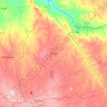
Name: Gulu topographic map, elevation, terrain.
Location: Gulu, Northern Region, Uganda (2.73659 32.18557 3.30358 32.65971)
Average elevation: 953 m
Minimum elevation: 693 m
Maximum elevation: 1,188 m
Other topographic maps
Click on a map to view its topography, its elevation and its terrain.
Mount Luigi di Savoia
Mount Luigi di Savoia, South Ridge Route, Kasese, Western Region, Uganda
Average elevation: 4,114 m
Rwenzori Mountains
Uganda > Bundibugyo > Sindila
Rwenzori Mountains, Sindila, Bundibugyo, Western Region, Uganda
Average elevation: 1,570 m
Mount Elgon
Mount Elgon, Bukwo, Eastern Region, Uganda
Average elevation: 3,762 m
Mukarange;Block 84
Uganda > Hoima > Mukarange;Block 84
Mukarange;Block 84, Hoima, Western Region, Uganda
Average elevation: 1,130 m
Coronation Glacier
Coronation Glacier, South Ridge Route, Kasese, Western Region, Uganda
Average elevation: 4,405 m
Mount Gessi
Uganda > Bundibugyo > Sindila
Mount Gessi, Sindila, Bundibugyo, Western Region, Uganda
Average elevation: 4,127 m