
Make a donation
Bihar topographic map
Click on the map to display elevation.
Make a donation
Bihar
Bihar covers a total area of 94,163 km2 (36,357 sq mi), with an average elevation above sea level of 173 feet (53 m). It is land locked by Nepal in the north, Jharkhand in the south West Bengal in the east and Uttar Pradesh to the west. It has three parts on the basis of physical and structural conditions: the Southern Plateau, the Shivalik Region, and Bihar's Gangetic Plain. Furthermore, the vast stretch of the fertile Bihar Plain is divided by the Ganges River into two unequal parts – North Bihar and South Bihar. The Ganges flows west–east and, along with its tributaries, regularly floods parts of the Bihar plain. The main northern tributaries are the Gandak and Koshi, which originate in the Nepalese Himalayas, and the Bagmati, which originates in the Kathmandu Valley. Other tributaries are the Son, Budhi Gandak, Chandan, Orhani and Phalgu. Bihar has some small hills, such as the Rajgir hills in center, Kaimur Range in south-west and Shivalik Range in North. Bihar has a forest area of 6,764.14 km2, which is 7.1 per cent of its geographical area. The sub-Himalayan foothills of Shivalik ranges, primary Someshwar and Dun mountain, in West Champaran district are clad in a belt of moist deciduous forest. As well as trees, this consists of brush, grasses and reeds.
Make a donation
About this map
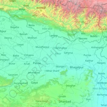
Name: Bihar topographic map, elevation, terrain.
Location: Bihar, India (24.28572 83.32126 27.52164 88.29380)
Average elevation: 605 m
Minimum elevation: 12 m
Maximum elevation: 8,114 m
Make a donation
Other topographic maps
Click on a map to view its topography, its elevation and its terrain.
Udupi
India > Karnataka > Udupi taluku
Udupi has an elevation of 27 m (89 ft) above mean sea level. The climate in Udupi is hot in summers and pleasant in winter. During summers (from March to May) the temperature reaches up to 38 °C (100 °F) and in winters (from December to February) it is usually between 32 and 20 °C (90 and 68 °F). As it is…
Average elevation: 17 m
Make a donation