
Richards Island topographic map
Interactive map
Click on the map to display elevation.
About this map
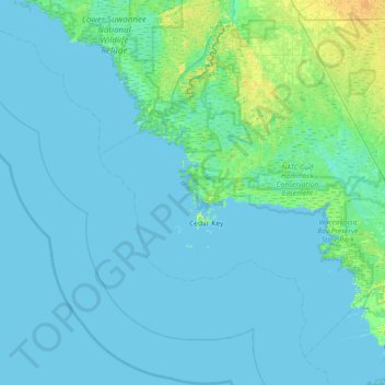
Name: Richards Island topographic map, elevation, terrain.
Location: Richards Island, Levy County, Florida, USA (28.86747 -83.38096 29.50747 -82.74096)
Average elevation: 3 m
Minimum elevation: 0 m
Maximum elevation: 24 m
Other topographic maps
Click on a map to view its topography, its elevation and its terrain.
Harbor Shores
USA > Florida > Harbor Shores
Harbor Shores, Lake County, Florida, 32735, USA
Average elevation: 23 m
Coral Gables
USA > Florida > Coral Gables
Coral Gables, Miami-Dade County, Florida, USA
Average elevation: 4 m
Altamonte Springs
USA > Florida > Altamonte Springs
Altamonte Springs, Seminole County, Florida, USA
Average elevation: 26 m
Dry Tortugas National Park
Dry Tortugas National Park, Monroe County, Florida, USA
Average elevation: 0 m
The Villages
USA > Florida > The Villages
The Villages, Lake County, Florida, USA
Average elevation: 27 m
St. Augustine
USA > Florida > St. Augustine
St. Augustine, St. Johns County, Florida, 32084, USA
Average elevation: 5 m
Deerfield Beach
USA > Florida > Deerfield Beach
Deerfield Beach, Broward County, Florida, USA
Average elevation: 5 m
Pembroke Pines
USA > Florida > Pembroke Pines
Pembroke Pines, Broward County, Florida, USA
Average elevation: 5 m