
Divriği topographic map
Interactive map
Click on the map to display elevation.
About this map
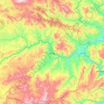
Name: Divriği topographic map, elevation, terrain.
Location: Divriği, Sivas, Central Anatolia Region, 58300, Turkey (39.06223 37.62741 39.69253 38.41739)
Average elevation: 1,604 m
Minimum elevation: 841 m
Maximum elevation: 2,797 m
Other topographic maps
Click on a map to view its topography, its elevation and its terrain.
Şanlıurfa
An important consideration in domestic architecture is mahremiyat, which could roughly be translated into English as "privacy" or "intimacy" but which carries stronger implications. This concept is especially important when it comes to relations between men and women – outside the extended family,…
Average elevation: 623 m