
Yavapai County topographic map
Interactive map
Click on the map to display elevation.
About this map
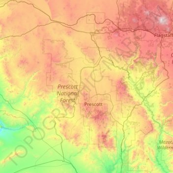
Name: Yavapai County topographic map, elevation, terrain.
Location: Yavapai County, Arizona, United States of America (33.88216 -113.33448 35.53065 -111.46127)
Average elevation: 1,433 m
Minimum elevation: 345 m
Maximum elevation: 3,757 m
The county's topography makes a dramatic transition from the lower Sonoran Desert to the south to the heights of the Coconino Plateau to the north, and the Mogollon Rim to the east. The highest point above sea level (MSL) in Yavapai County is Mount Union at an elevation of 7,979 ft (2,432 m) and the lowest is Agua Fria River drainage, now under Lake Pleasant.
Other topographic maps
Click on a map to view its topography, its elevation and its terrain.
Maricopa County
United States of America > Arizona
Maricopa County, Arizona, United States of America
Average elevation: 549 m
Darling
United States of America > Arizona > Winona
Darling, Winona, Coconino County, Arizona, United States of America
Average elevation: 1,916 m
Pima County
United States of America > Arizona
Pima County, Arizona, United States of America
Average elevation: 807 m