
Thank you for supporting this site ❤️
Make a donation
Make a donation
Istanbul topographic map
Click on the map to display elevation.
Thank you for supporting this site ❤️
Make a donation
Make a donation
About this map
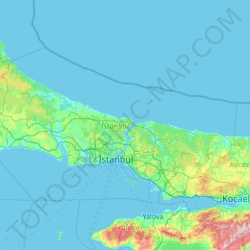
Name: Istanbul topographic map, elevation, terrain.
Location: Istanbul, Marmara Region, Turkey (40.73767 27.97085 41.67100 29.95880)
Average elevation: 74 m
Minimum elevation: -4 m
Maximum elevation: 1,343 m
Thank you for supporting this site ❤️
Make a donation
Make a donation
Other topographic maps
Click on a map to view its topography, its elevation and its terrain.
Şanlıurfa
An important consideration in domestic architecture is mahremiyat, which could roughly be translated into English as "privacy" or "intimacy" but which carries stronger implications. This concept is especially important when it comes to relations between men and women – outside the extended family,…
Average elevation: 623 m