
Leeds topographic map
Interactive map
Click on the map to display elevation.
About this map
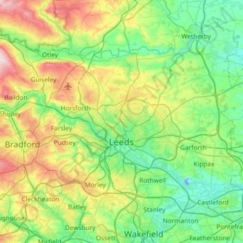
Name: Leeds topographic map, elevation, terrain.
Location: Leeds, Yorkshire and the Humber, England, United Kingdom (53.69897 -1.80042 53.94587 -1.29035)
Average elevation: 96 m
Minimum elevation: -15 m
Maximum elevation: 356 m
Other topographic maps
Click on a map to view its topography, its elevation and its terrain.
West Yorkshire
United Kingdom > England > Leeds
West Yorkshire, Wharf Approach, Steander, Holbeck Urban Village, Leeds, Yorkshire and the Humber, England, LS1 4GJ, United Kingdom
Average elevation: 172 m