
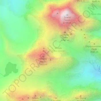
Middle Teton Glacier topographic map
Interactive map
Click on the map to display elevation.
About this map
Name: Middle Teton Glacier topographic map, elevation, terrain.
Average elevation: 3,383 m
Minimum elevation: 2,803 m
Maximum elevation: 4,184 m
Other topographic maps
Click on a map to view its topography, its elevation and its terrain.
Teton Glacier
USA > Wyoming > Beaver Creek
Teton Glacier, Garnet Canyon Trail, Beaver Creek, Teton County, Wyoming, USA
Average elevation: 3,307 m
Teepe Glacier
USA > Wyoming > Beaver Creek
Teepe Glacier, Garnet Canyon Trail, Beaver Creek, Teton County, Wyoming, USA
Average elevation: 3,338 m